This field manual package aims to provide a standardised national methodology for the acquisition of marine data from a prioritised set of frequently-used sampling platforms (below diver depths) so that data are directly comparable in time and through space. This will then facilitate national monitoring programs in Australian open waters and contribute to the design of an ongoing monitoring program for AMPs. The long-term goal is to produce a set of manuals that is applicable to a broad range of users and to be prescriptive enough that all data are collected without unnecessary technical variation.
Survey planning
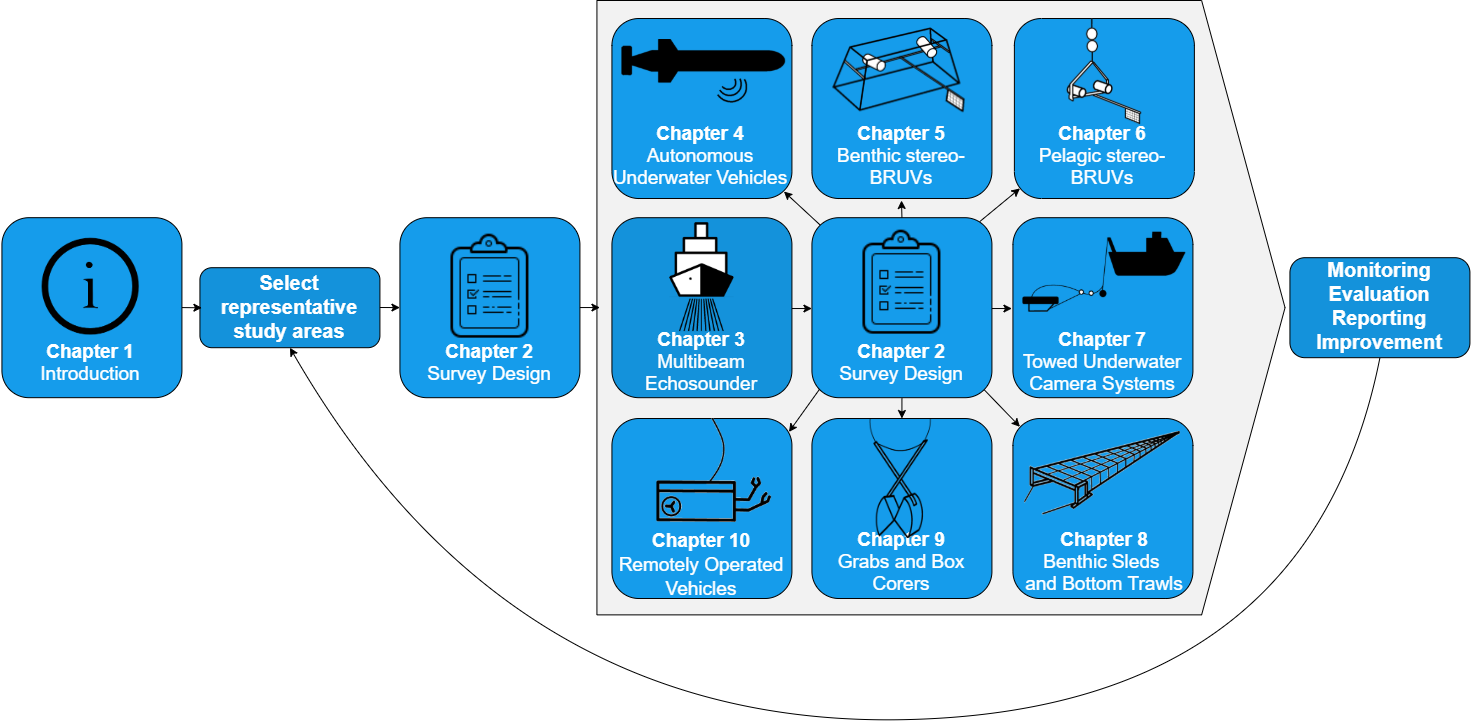
We strongly advise that survey design should be considered at all levels of planning (Figure 1), as it is essential to ensure sampling provides efficient and representative information to inform management (Hayes et al., 2019). If information is lacking, then evidence-based decision frameworks, e.g. a Monitoring Evaluation, Reporting and Improvement (MERI) framework, cannot proceed without being compromised. Chapter 2 of this field manual package provides details of sampling design considerations and how they can be navigated, as well as example code and data for implementing a spatially-balanced design, as outlined in Foster et al. (2017) and Foster et al. (2019). Chapter 2 also emphasises the foundational role of seafloor data from sonar (Chapter 3), which can facilitate the production of base maps covering tens or hundreds of square kilometres, with accurate geo-location. These maps can form the input needed to generate an efficient spatial survey design. Where no seafloor data exists, the principles in Chapter 2 can also be used to design efficient and representative sonar surveys.
 Figure 1: Recommended role of Survey Design (Chapter 2) in Survey Planning, including the foundational role of seafloor data from multibeam sonar (Chapter 3), to inform sampling (Chapters 4-11) and management frameworks (e.g. a Monitoring Evaluation, Reporting and Improvement framework).
Sampling platforms
We generally limit our field manuals to benthic biological sampling, with a few exceptions described above for Chapters 6, 12, and 13. These field manuals focus on data acquisition and post-processing including data management, particularly as applied to marine monitoring. Standardisation of sampling design is important to ensure rigor and reproducibility (National Academies of Sciences, Engineering, and Medicine 2019) and is addressed accordingly in Chapter 2. Data analysis and reporting are generally not included in the field manuals, although we direct users to useful methods or resources within each field manual.
For most field manuals, a scope specific to that particular sampling gear and data type is presented in a separate section. Overall, these field manuals are meant to cover basics and important considerations, with agency- and gear-specific SOPs supplemented as needed by individual researchers. Detailed and gear-specific SOPs are outside the scope of this field manual package due to the large number of existing SOPs and the variety of gear currently employed by researchers. It is impractical that researchers would agree on detailed SOPs (and associated gear). Rather, we have developed these field manuals to find consensus about as many issues as possible, while noting the differences. These differences can then be assessed in the future (e.g. they may not correspond to large amounts of variation in data), and addressed if need be. Wherever possible, however, we have mandated or recommended specifications (e.g. imagery resolution) that should be used in future equipment upgrades or purchases.
This field manual package does not describe the decision to use a particular sampling platform, supporting previous recognition that a top-down, one-size-fits-all approach to monitoring is unlikely to be effective in systems with large environmental variability (Fancy et al. 2009). In some instances, multiple platforms will yield higher observed diversity (e.g. BRUVS + a transect-based imagery platform), while data collected among other platforms are comparable (e.g. ROV, diver-operated video, towed video, Schramm et al 2019). For a more detailed review of each sampling platform, as well as a comparative assessment among them, we refer readers to our companion reports on benthic (Przeslawski et al. 2018) and pelagic (Bouchet et al. 2018) sampling methods used in marine monitoring. These reports also relate marine sampling platforms to Essential Ocean Variables (Miloslavich et al. 2018, Muller-Karger et al. 2018). After the decision to use an appropriate sampling platform has been made, using the appropriate field manuals will help ensure that the collected data can be compared with data collected previously and in the future, thus contributing to national marine monitoring and reporting.

